
Day 65: June 6, 2026
Will fights a "whack-a-mole" battle against the snow and slush of the Melville Hills, pushing, learning, and adjusting his plan to make a tactical descent to easier terrain.
-
Hello, yes, it's Will here. It's June 6th, day 64 here. And you're following yesterday. I've got into some really difficult slush and just real heavy going with this pack. It weighs about 80 pounds and way too low. But I'm down to bare essentials given I need the proper food. And, you know, given you're down and everything else that you need for hypothermia, it's pretty hard to reduce that load. And I'm also bringing back communication gear. That's the problem. If I get rid of that, I'd be a little lighter, but that's not an option. So I'm stuck with a heavy load over this really tough terrain.
And there's this large dome that sticks out in the terrain. In fact, there's a lot of high places like that around. And the valleys are very high. And they're almost like a plateau at the top. And this is called the Melville Hills. It's a really rugged area, 100 by 200 miles or so. And I repeated this before, but just for someone who tuned in: four years ago, I was having maps of this region trying to figure out a good route that was really challenging. And I settled for the route that I did this year. And the holy grail of it was this big dome that was 1,500 feet. It was just very gradual. It was really steep. My first day, very steep. The actual cliffs that I had to get around to get up there and then an incline. And then I traveled on the surface. At first, it was pretty good going as I could ascend it up. But then I got into this unusual situation.
And I'm going to do an ABC or thing on tundra just to explain. Tundra is, of course, permanently frozen ground. And just a little generalization. But in tundra, especially in this area and all that's universal, there's kind of two formations that you get. You get these tussocks that are little mounds that grow up. They can be six inches to two feet. And then they can be grassy. Or in this area, these little tussocks are not ... they stick out. And there's depressions in between them. They're mostly mossy. They're really pretty. Real ankle breaker. But they're not stone. They're soft. And so you have the tussocks. And you have the other area in this area where it's from frost heaving. Here at frost, it heaves up modden kind of chipped rock. And sometimes there's these unusual circle formations. You think someone was up there, you know, doing that. But that's a normal situation.
On the flat tundra you have that situation. And when I first started out, that was not too much of a problem. They were dry at first. And then there was some frozen ice in it. But as I got further up, and it happened actually on the ascent up on the dome. But it was not flat ground, but ground that was just steadily going up. There was a lot of water between these tussocks and that, and in between the tussocks. And in some places, you know, it's about a foot deep. But what was happening here, this is because I'm in higher elevation. At the very top of this dome is all snow and slush. And this is actually late in the season. It hasn't really [...] up totally. The tundra is also like a sponge. It holds as much water as it can for as long as it can, and then it flows down. Well, in this case, I got to the dome, it was flat. And there was water from, ankle deep and knee deep and some places deeper. But then there's a crust of snow and then some snow, then there's some slush. So I was post-holing into this slush. I mean, it was just unbelievable. But it was very interesting, as really, as my body got treated here in the last couple of days just to understand that.
So I experienced this in a late, late situation, which I did not expect. I mean, I laid out plans, of course. But there's a couple of things. One is a plan. You're going to do this and that. And then if you don't do the plan, people say, well, you failed. And plans are important when you're dealing with people's times and efforts. And we always lay out plans and we want to be as certain as possible. But when you're exploring or, in this case, going into, I'm not exploring because this is math, but no one really travels here this season or hardly at all, any. But there's a lot of unknowns and a lot of seasonal and it's a late season and all sorts of changes. So I lay out a strategy.
And the last first three days here, actually the last two have been really tough. But I'm starting to learn the country. First of all, learning that I was going to take a route that was higher up to avoid the rivers. I was basically going to take a route on the divide. Well, I found out now because it's later in the season, that's not feasible because of what I went through the last couple of days. And then also in the adjacent high countries, there's deep valleys. It's just a stunningly beautiful country. Deep valley and it's lightly forested. You know, it's green down there. You can feel all this. And then up on the other side, maybe 10 miles, maybe 15 miles, another height like that where I was on. And you see like a real thin white line on the top. And that was that kind of like a little ice cap temporary thing that I was in.
And today, I knew it was going to be a tough day. The first two miles, I had almost all of this stuff. It was like whack-a-mole. It got worse and worse. And getting into the second mile, there was no place at all to rest. I was in the crust, making through the crust up to my knees. My feet were in the mush. And this heavy pack was just killing me. But so I pushed through. And my goal was now for the day to make a quick descent. The northeast side of this dome descends pretty rapidly. So I was able to lose about 300 feet. And in these conditions, 100 feet makes a big, big difference. And on the northeast side of the dome, it doesn't face the sun. It is a lot of snow.
So I descended back down to the bottom. There's a small river that I had to cross. And I was really surprised just how much water was in that river. I didn't expect that much. But it's still flowing. And then I got to the spot I made camp early. But this took about six, seven hours to get here. So part of the plan here is I'm going to take tomorrow off to rest myself. I'm really overexerted. I'm okay. But you get in this expedition mode where you want to keep pushing. Well, you know, I've got to get out for a day here to recuperate. Eat some food. Get my weight down a little bit. And then I'll start off again. I've got a river crossing up ahead. I'll prepare for that. And then I may travel three days, two days, three days probably, and then another day off. But this is, you know, turned out to be a really exciting thing. I don't know how long this is going to turn out. But my batteries are low here. So I've got to sign off. This is Will. June 6, day 64, over and out.
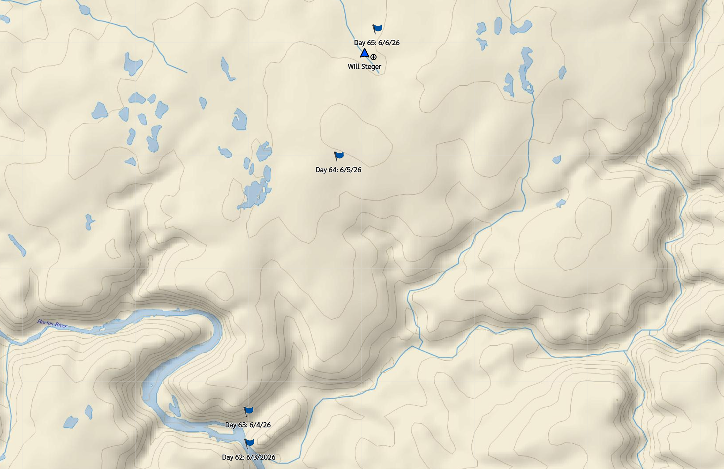
Will descended 300 feet from the height where he previously camped, looking to get out of the slush to ground with better footing. Visit Will’s interactive map for complete control of magnification and orientation.

Heavy packs wheeling through the airport at the outset of the 2023 solo expedition. Pack weight is presenting an issue on the flooded tundra in today’s dispatch.